In most of the movies depicting the Battle of the Alamo, the fort is shown off in the distance, far away from any town. But in reality, this is far from accurate.
We must remember that the Alamo was first a mission and a church, serving not only the Indians within its walls but also the communities that grew around it. At the time of the battle, there were three communities near the Alamo: Pueblo de Valero, La Villita, and Bexar. Bexar was the largest and sat just across the San Antonio River; in fact, the town’s Main Plaza was only about 400 yards from the fort. La Villita was on the same side of the river as the Alamo, just a little further to the south. La Villita was close enough that two Mexican artillery batteries were placed there. Pueblo de Velero was the closest and the smallest of the three. It was but a collection of “jacales” (thatched huts) huddled near the Alamo’s main gate. So close were these jacales to the Alamo that they were in the very shadow of the fort’s walls.
So, to experience the complete story of the Alamo, we must journey beyond its walls and explore more of the city for its other historic sites.
This post was updated on April 16, 2022
The Menger Hotel
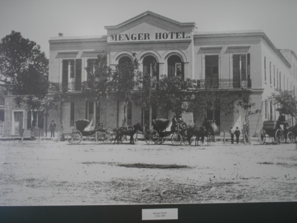
Photo from Wikipedia
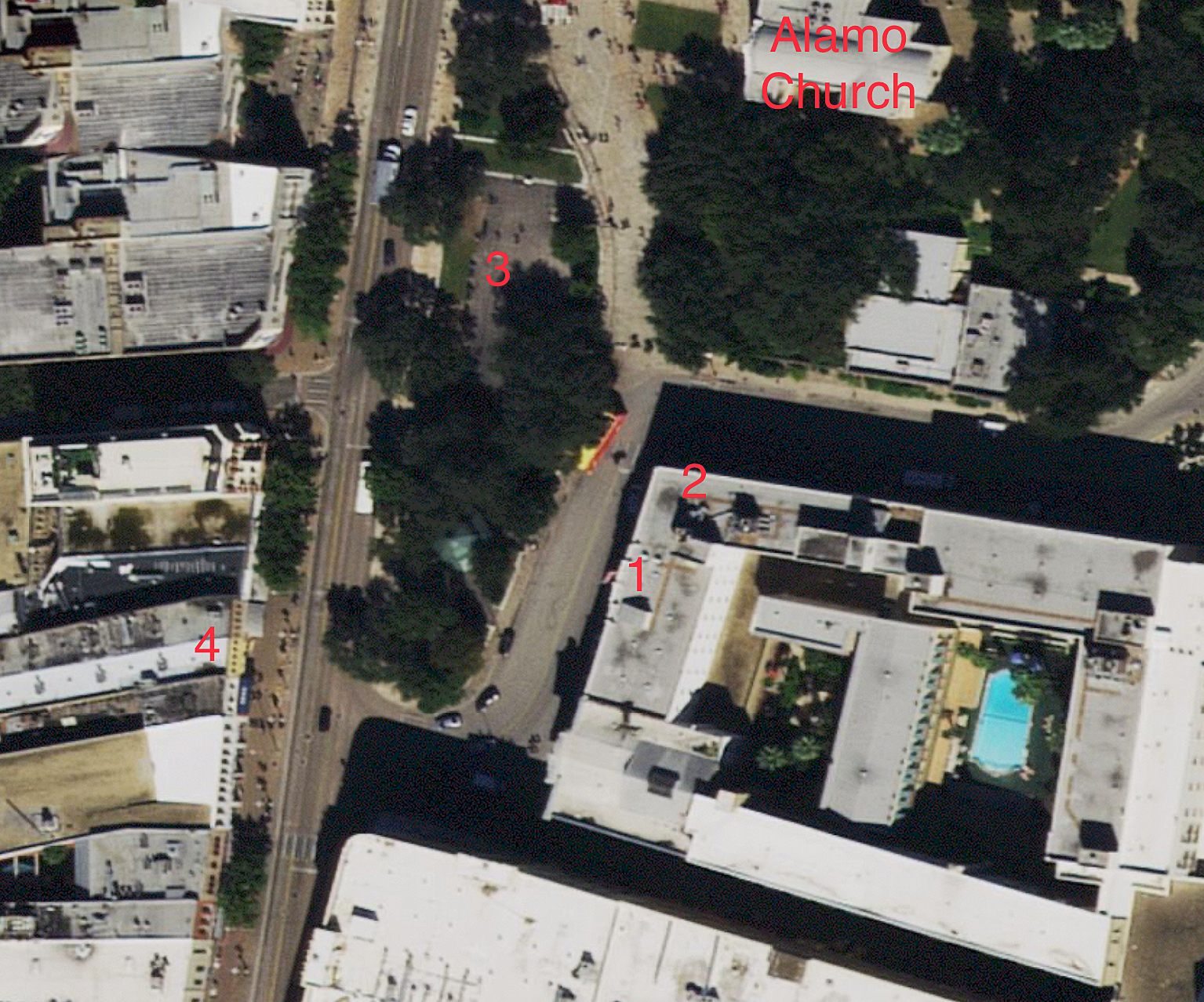
Before we leave Alamo Plaza, there’s another stop we need to make, and that’s to the historic Menger Hotel (See map #1). The Menger Hotel isn’t hard to miss; it’s located on the east side of Alamo Plaza, directly across Crockett Street from the Alamo, on the corner.
Even though the Menger Hotel isn’t part of the 1836 Battle of the Alamo, it’s still a major historical site. The Menger opened on January 31, 1859, by German immigrant William Menger. Today, the Menger holds the title of being the oldest continually operated hotel west of the Mississippi River. In its day, the Menger was one of the most renowned hotels in the country, as it hosted a wide array of famous guests, including twelve U.S. Presidents. The Menger is also known as “the most haunted hotel in Texas.”
There’s one section of the hotel that’s a must to visit, and that’s the Menger’s Bar (See map #2). You enter the bar on the hotel’s north side, just around the corner.
The Menger’s Bar
In 1887, the hotel’s manager, Hermann Kampmann, constructed a new bar for the hotel. The design was a replica of the taproom in the House of Lords Club in London, England. Outfitted with a solid cherry wood bar, cherry paneled ceilings, French mirrors, and gold-plated spittoons, it was the perfect expression of Victorian-era male design.
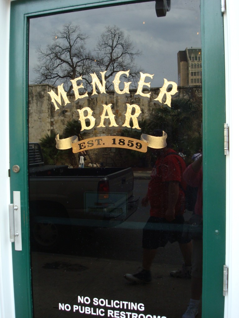
Photo by author
This ornate bar would be the site of two outstanding historical events: the forming of the most famous regiment of the Spanish-American War, and the appearance of the most infamous representative of the U.S. temperance movement.
The Rough Riders
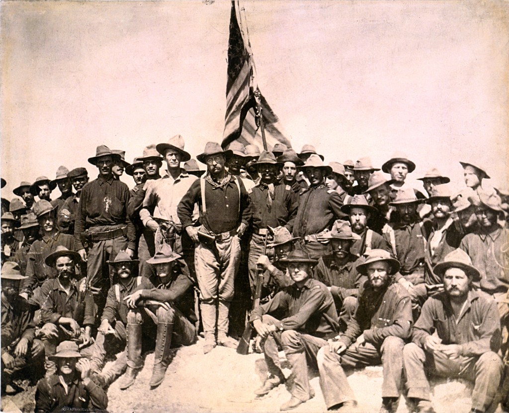
Photo from Wikipedia
Future President Theodore “Teddy” Roosevelt had returned to San Antonio in May of 1898, after a six-year absence. War had broken out in April between the United States and Spain, and he had come to Texas to recruit hard-fighting and hard-riding Texans for the war.
It was in the Menger’s Bar where Roosevelt had gathered to recruit men for his First United States Volunteer Cavalry Regiment. This regiment at first was famously nicknamed “Roosevelt’s Rough Riders,” then just “the Rough Riders.” The bar still pays tribute to this event with displays of Roosevelt’s uniform and other memorabilia.
Carrie Nation
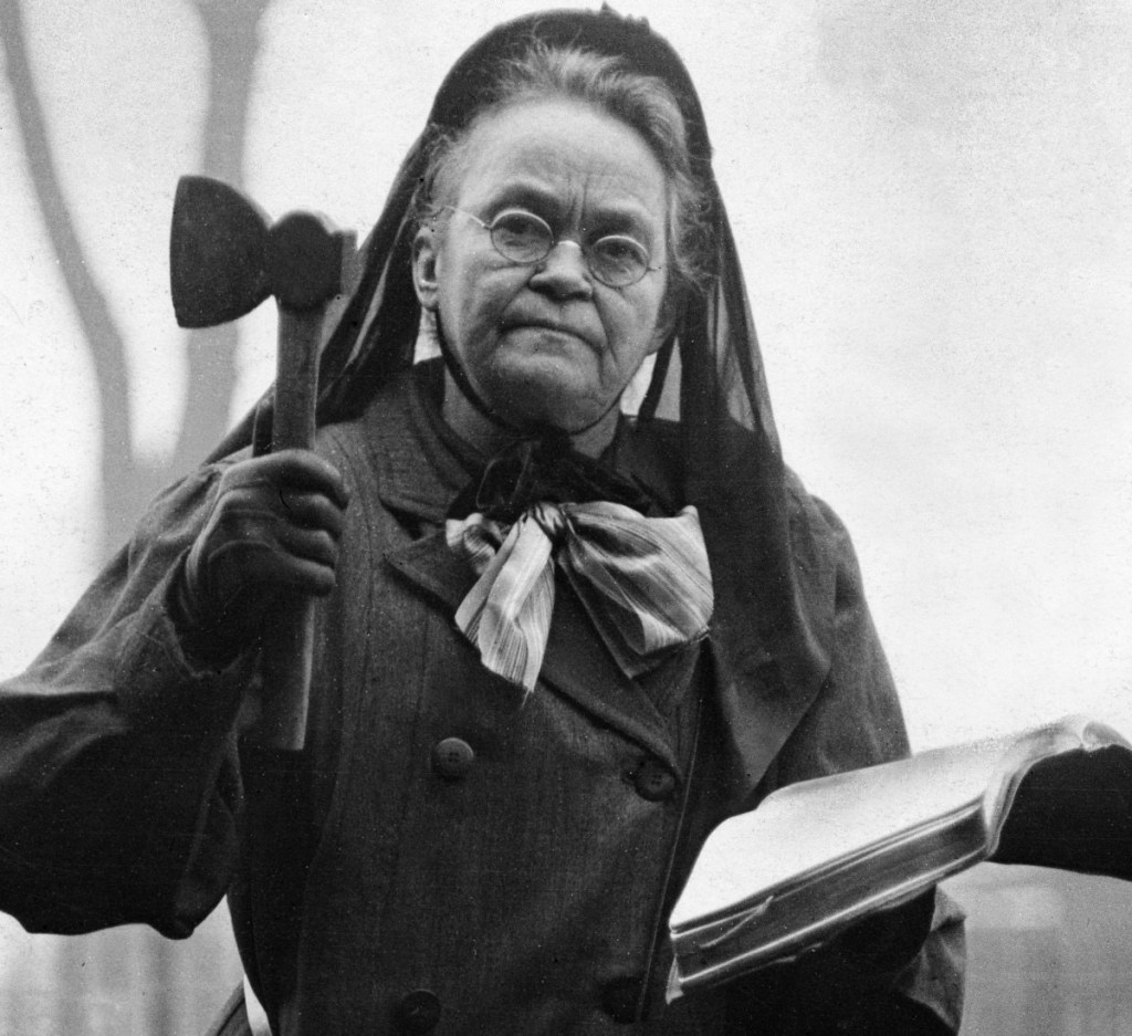
Photo from Wikipedia
The other event was not so welcoming. Long before prohibition, there was an anti-alcohol-drinking drive known as the temperance movement. The most active group in this movement was the Women’s Christian Temperance Union. This organization’s most radical member was a woman named Carrie Nation.
Carrie Nation’s mission was to raid drinking establishments, tearing up the barrooms and destroying their stocks of beer and whiskey. Often she would be accompanied by a group of women, who would sing hymns and pray, while Nation would use a hatchet in doing her work; the term she used was “Hatchetation.”
It was only inevitable that Nation would arrive at the well-known Menger Bar. Evidence of her visit can still be seen today. Near the corner of the bar is a section of mismatched wood; it’s there that they say Carrie Nation had buried her hatchet.
Plaza de Valero and Pueblo de Valero
Photo by author
We’ll now leave the Menger Hotel and go back onto Alamo Plaza. The southern section of the plaza was originally called Plaza de Valero (See map #3). Plaza de Valero encompassed the open area that was in front of the Alamo’s main gate.
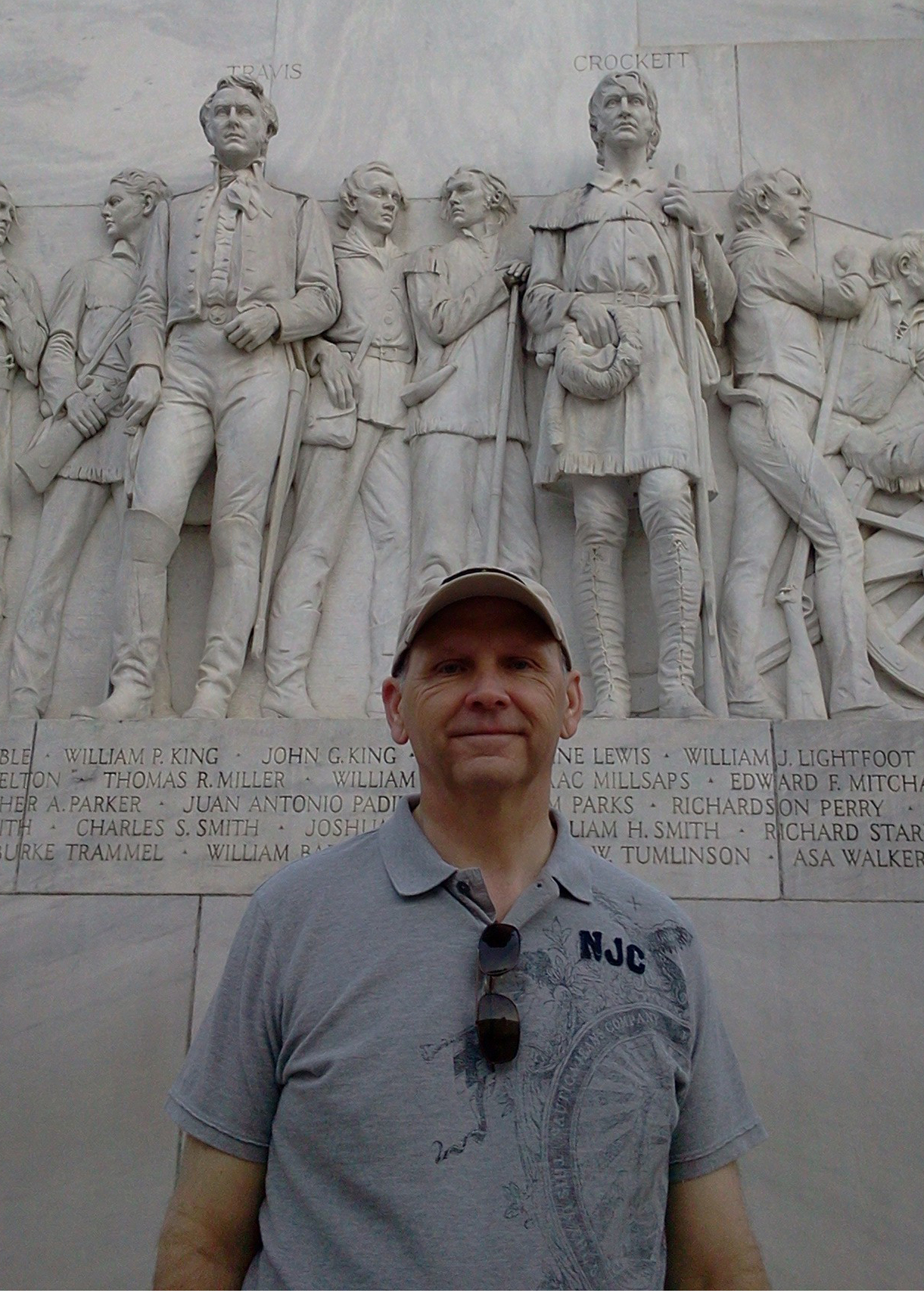
Surrounding the plaza were the jacales that made up the Pueblo de Valero (See map #4). During the 1836 siege, because of the closeness, these huts were to the Alamo, a small group of defenders, including David Crockett, had tried to burn them down to remove the cover for the Mexican soldiers.
After the ruined Low Barrack was removed in 1871, the Plaza de Valero and Alamo Plaza were joined, creating one large and open plaza.
We’re now going to walk south along Alamo Plaza Street, leaving the Alamo and Alamo Plaza behind.
The East Commerce Street Bridge
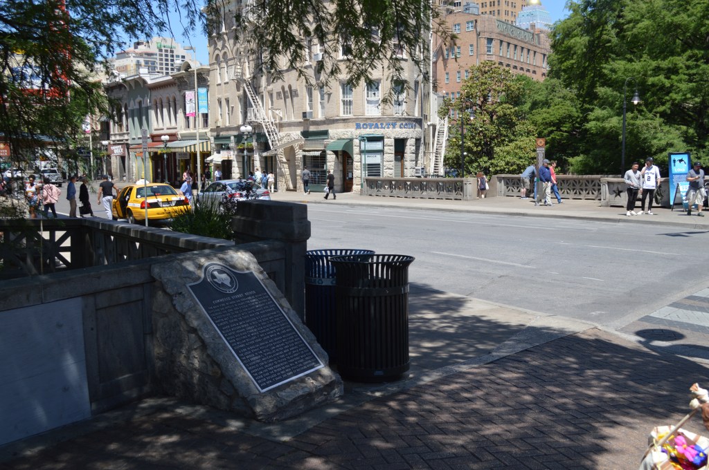
Photo by the author
When you get to the intersections of Losoya, Alamo, and East Commerce Streets, you’ll find the East Commerce Street Bridge (See map #5). In 1836, there was a small bridge at that location that joined Portreo Street, on the west side of the river, with Alameda Road on the east side. This small bridge was the only connector between the town of Bexar, Pueblo de Valero, La Villita, and the Alamo. This bridge had an essential role in the early days of the Alamo’s 13-day siege.
On the afternoon of February 23rd, 1836, the first day of the siege, the defenders and their families used this bridge to flee Bexar to take refuge in the Alamo. However, this bridge was also the site of an even bigger encounter that day.
Later that same afternoon, Santa Anna ordered the blood-red banner of “no quarter” to be raised from the San Fernando church’s bell tower. Seeing this, Travis ordered a shot fired from the fort’s big 18-pound cannon.
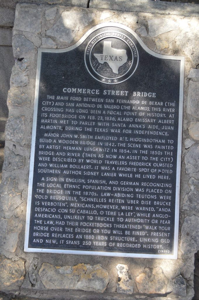
Photo by author
Fearing that Travis may have been a little too hasty, James Bowie sent Green B. Jameson to meet with Mexican Colonel Juan Almonte on that bridge. The purpose was to see if Santa Anna would be willing to have a parley. Hearing what Bowie had done, Travis then sent his own representatives. Both groups were given the same answer from Colonel Almonte: surrender at Santa Anna’s discretion, or be put to the sword. Hearing this, Travis answered with another cannon shot, and the battle of the Alamo had begun.
When you cross over to the south side of Commerce Street, you’ll find a historical plaque (See map #6) that gives the whole history of what took place there.
Site of the Alamo Defender’s Funeral Pyres, Maybe?
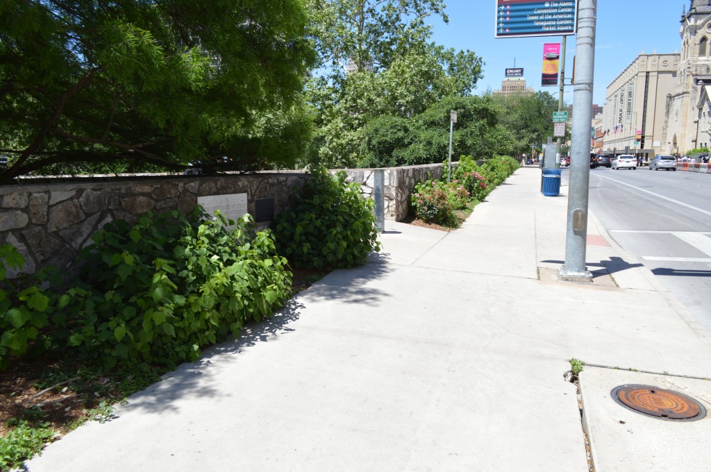
Photo by author
We’ll now cross over South Alamo Street and head east along the south side of East Commerce Street. What we’re on our way to see is what remains of one of the Alamo’s biggest mysteries, where the funeral pyres of the Alamo defenders were located.
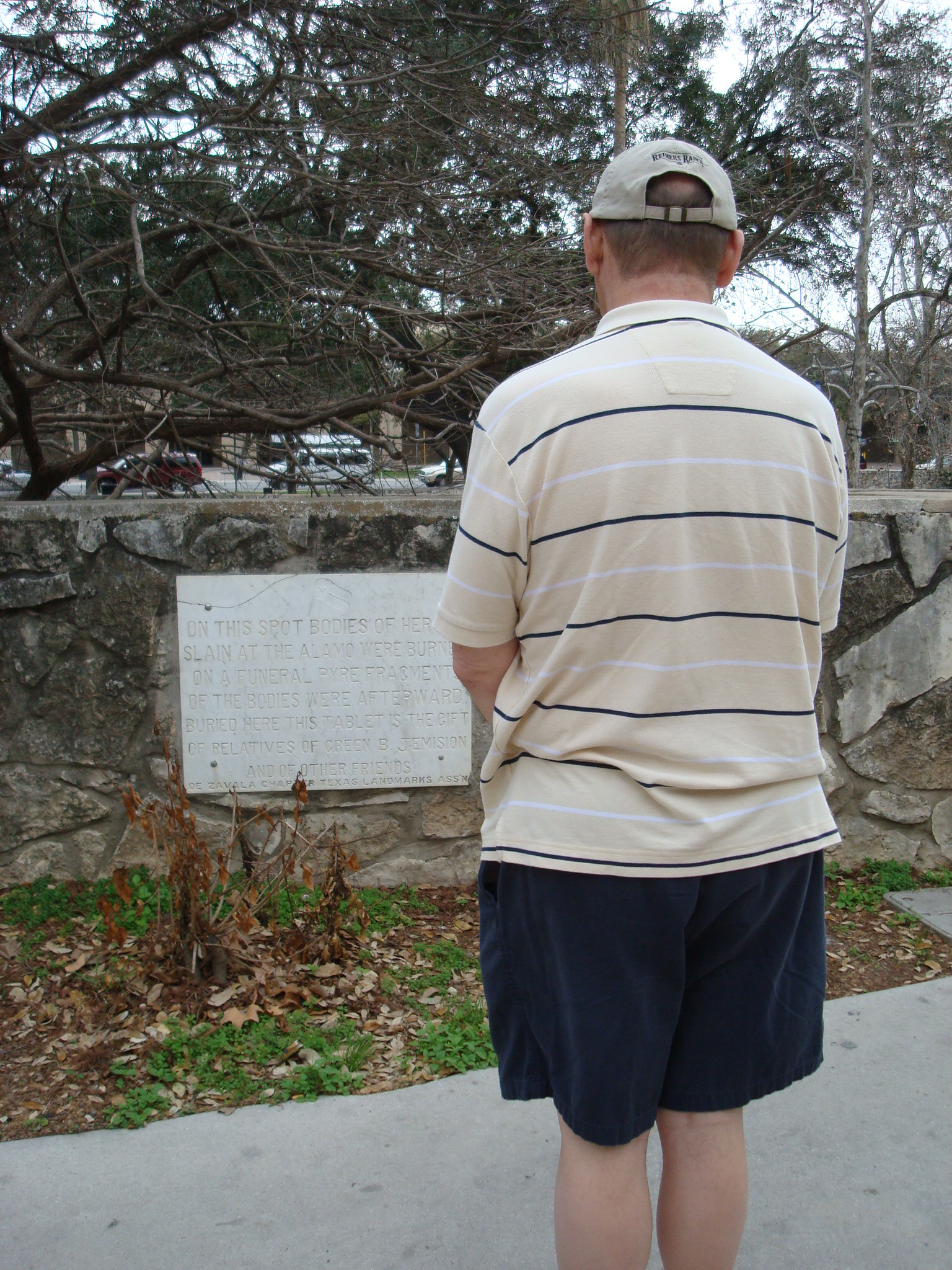
After the fall of the Alamo, General Santa Anna ordered that all the bodies of the Alamo defenders be gathered up and taken to what is now East Commerce Street. There, he had two pyres constructed of wood and bodies, which were then set on fire. On March 6th, 1917, on the 81st anniversary of the fall of the Alamo, historian and preserver of the Alamo, Adina De Zavala, placed two marble markers at what were believed to have been the sites of those pyres. However, over the years, these sites were lost, and only one of those markers was saved. And this is what we’re off to see.
After passing the San Antonio Chamber of Commerce building, we’ll follow the low stone wall to where it opens to the walkway down to the Paseo del Rio. Just past this opening, you’ll see two markers mounted on the stone wall; one marble and the other metal (see map #7).
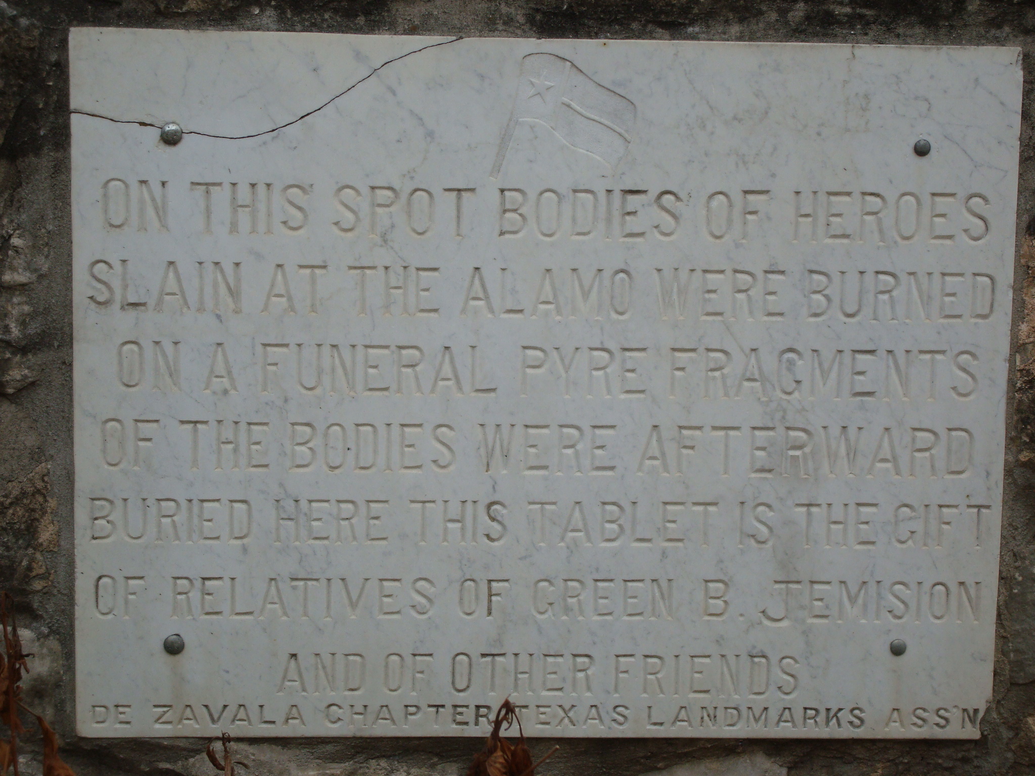
This marble marker is the original marker by De Zavala, and it reads,
ON THIS SPOT BODIES OF HEROES SLAIN AT THE ALAMO WERE BURNED ON A FUNERAL PYRE. FRAGMENTS OF THE BODIES WERE AFTERWARD BURIED HERE. THIS TABLET IS THE GIFT OF RELATIVES OF GREEM B JEMISON AND OF OTHER FRIENDS.DE ZAVALA CHAPTER TEXAS LANDMARKS ASSN
But this inscription isn’t quite correct; this wasn’t the spot of one of the pyres. And this is explained on the metal marker, which reads,
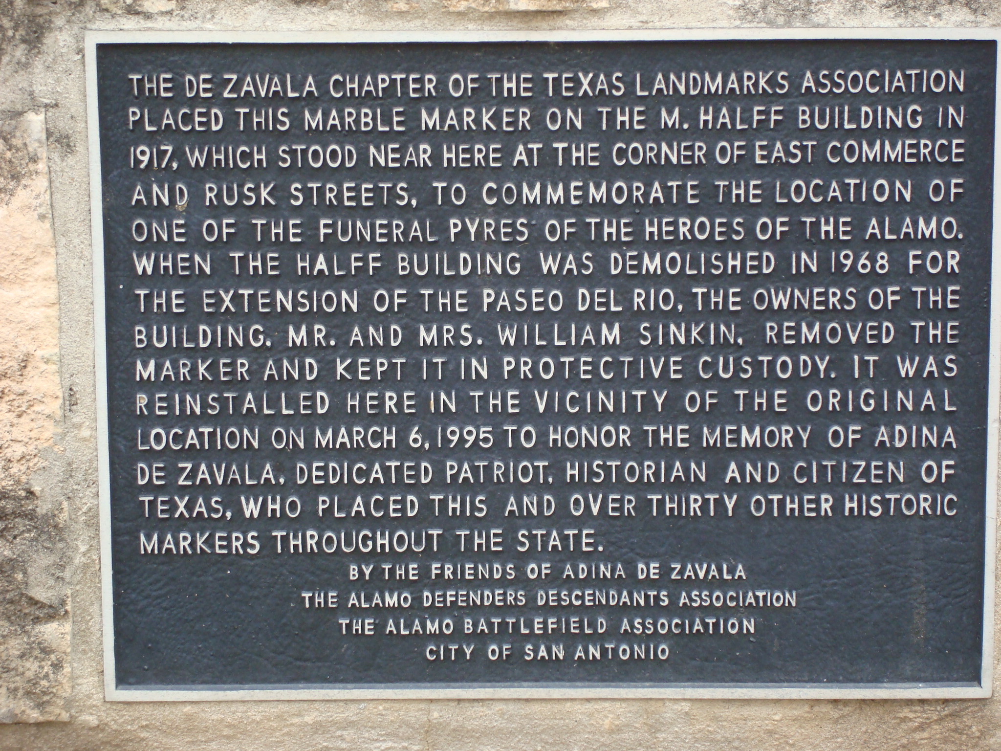
THE DE ZAVALA CHAPTER OF THE TEXAS LANDMARKS ASSOCIATION PLACED THIS MARBLE MARKER ON THE M. HALFF BUILDING IN 1917, WHICH STOOD NEAR HERE AT THE CORNER OF EAST COMMERCE AND RUSK STREETS, TO COMMEMORATE THE LOCATION OF ONE OF THE FUNERAL PYRES OF THE HEROES OF THE ALAMO. WHEN THE HALFF BUILDING WAS DEMOLISHED IN 1968 FOR THE EXTENSION OF THE PASEO DEL RIO, THE OWNERS OF THE BUILDING, MR. AND MRS. WILLIAM SINKIN, REMOVED THE MARKER AND KEPT IT IN PROTECTIVE CUSTODY. IT WAS REINSTALLED HERE IN THE VICINITY OF THE ORIGINAL LOCATION ON MARCH 6, 1995 TO HONOR THE MEMORY OF ADINA DE ZAVALA, A DEDICATED PATRIOT, HISTORIAN, AND CITIZEN OF TEXAS, WHO PLACED THIS AND OVER THIRTY OTHER HISTORIC MARKERS THROUGHOUT THE STATE.
BY THE FRIENDS OF ADINA DE ZAVALA
THE ALAMO DEFENDERS DESCENDANTS ASSOCIATION
THE ALAMO BATTLEFIELD ASSOCIATION
CITY OF SAN ANTONIO
As stated on the metal marker, this location is only in the vicinity of the original. The actual locations of those pyres are up for debate and are an intriguing and involved story in themselves. Because of this, I’m devoting an entire series of posts just to this subject, “Where are the Remains of the Alamo Heroes?”
To get to our following site, we need to go back the way we came, crossing to the west side of South Alamo Street and then turning left.
The Cos House
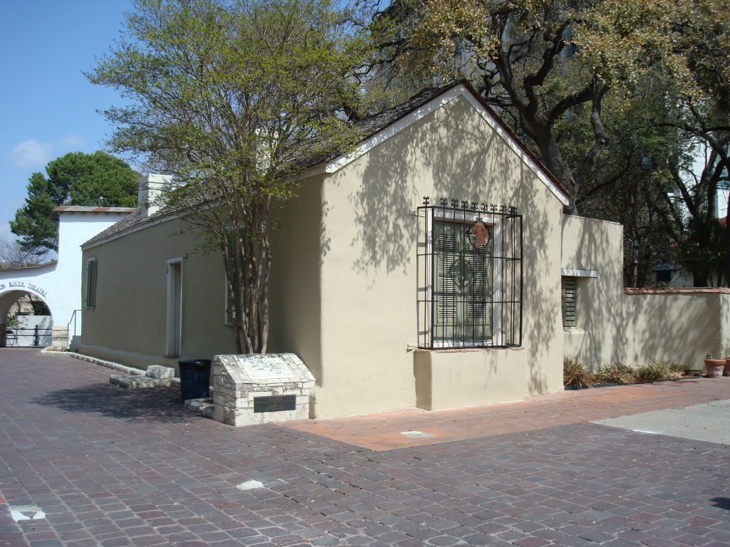
Photo by author
Our next stop is the site of a significant event that took place in the early days of the Texas Revolution.
Shortly after the “Come and Take It” Battle of Gonzales on October 2, 1835, Texas erupted into an open revolution. On October 12th, close to 600 Texan Revolutionaries surrounded the town of San Antonio de Bexar. There, they had trapped Mexican General Martin Perfecto de Cos and his 1,200 men in the town and the Alamo.
On December 5, the Texans launched a surprise attack on the town and the Alamo. For five days, the Texan rebels and Mexican soldiers fought a fierce house-to-house battle. Finally, on December 9, General Cos called for terms of surrender, coming to an agreement on December 10th. The agreement was that Cos and his troops would be paroled back across the Rio Grande and never again raise arms against Texas. Cos and his men never made it back before they met Santa Anna and his army heading north. There they were turned around and took part in the Battle of the Alamo.
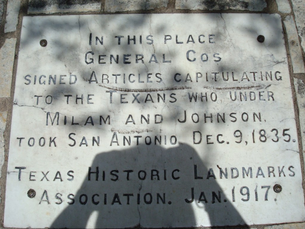
Photo by author
In La Villita, there’s a building known as the Cos House. Local lore says that it was there that General Cos signed the terms of surrender on December 11th.
To find the Cos House from East Commerce Street, we need to walk south along South Alamo Street. When you get to La Villita Street, turn right; the Cos House (See map #8) is just a short distance in. While in historic La Villita, be sure to visit its many artisan shops.
We’re now going to take a little longer walk to one of my most significant and most rewarding new surprises, thanks to author Dean Kirkpatrick and his book, The Alamo Story and Battleground Tour.
Discovering the Old San Fernando Church
In his book, Kirkpatrick revealed a vital piece of Alamo history that I had believed lost. If I had only looked a little harder, I would have found it years ago. To see what Kirkpatrick had pointed out, we need to go to the city’s Main Plaza and the San Fernando Cathedral. To get there from La Villita, we’ll walk back to East Commerce Street and turn west across the bridge. The cathedral is only a short four blocks from there.
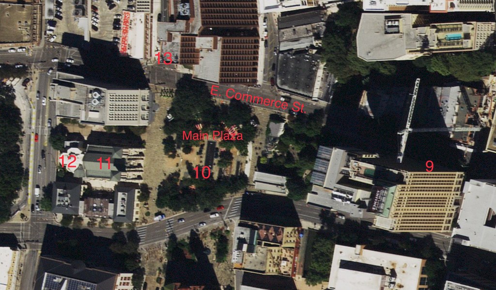
Just a few blocks from the river, you’ll pass the Drury Plaza Hotel (See map #9), and it’s here that we’ll make a quick stop. Although this building isn’t part of the Alamo’s history, it is part of San Antonio’s.
Drury Plaza Hotel San Antonio Riverwalk
Initially constructed in 1929 as the Alamo National Bank Building, it was an impressive 24 stories. At that height, it’s still one of the tallest buildings in the city. Trimmed in granite, marble, molded plaster, embellished terra cotta, decorative bronze, and stained glass, it was a central showplace for the city. In 2005, it was placed on the National Register of Historic Places. The Drury Hotel chain opened it as the Drury Plaza Hotel San Antonio Riverwalk in 2007.
The Alamo Church in Stained Glass
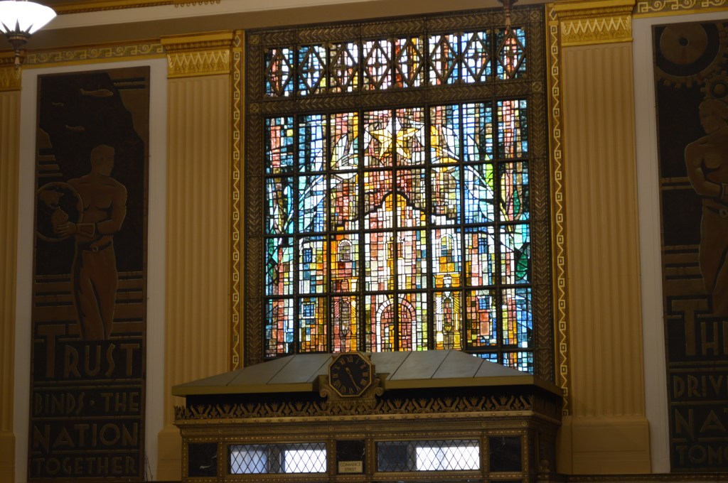
Photo by author
When you walk inside, the 50-foot ceilings of the main lobby, with its original chandeliers, will amaze you. But what I want you to do is walk to the center of the lobby, turn, and look above the main door. There you’ll see the most beautiful stained glass depiction of the Alamo Church; it will take your breath away.
Now back to our quest to find the original San Fernando Church. Leaving the hotel, we’ll continue west along East Commerce for just a couple of blocks more. Soon you’ll come to a big open area; this is the Main Plaza (See map #10).
The Main Plaza
This plaza was created by Spanish Captain Juan Antonio Pérez de Almazán when he laid out the streets of San Fernando de Béxar (San Antonio’s original name) in July of 1731. He designed this plaza, which he named Plaza de les Yslas, as the center of the town, with its streets radiating out from it. This plaza also holds an essential place in the Battle of the Alamo’s history. It was here on February 23, 1836, that Santa Anna made his grand entrance into the town on the first day of the siege.
On the west side of the plaza is the impressive twin-towered stone San Fernando Cathedral (See map #11). This is our destination.
The San Fernando Cathedral
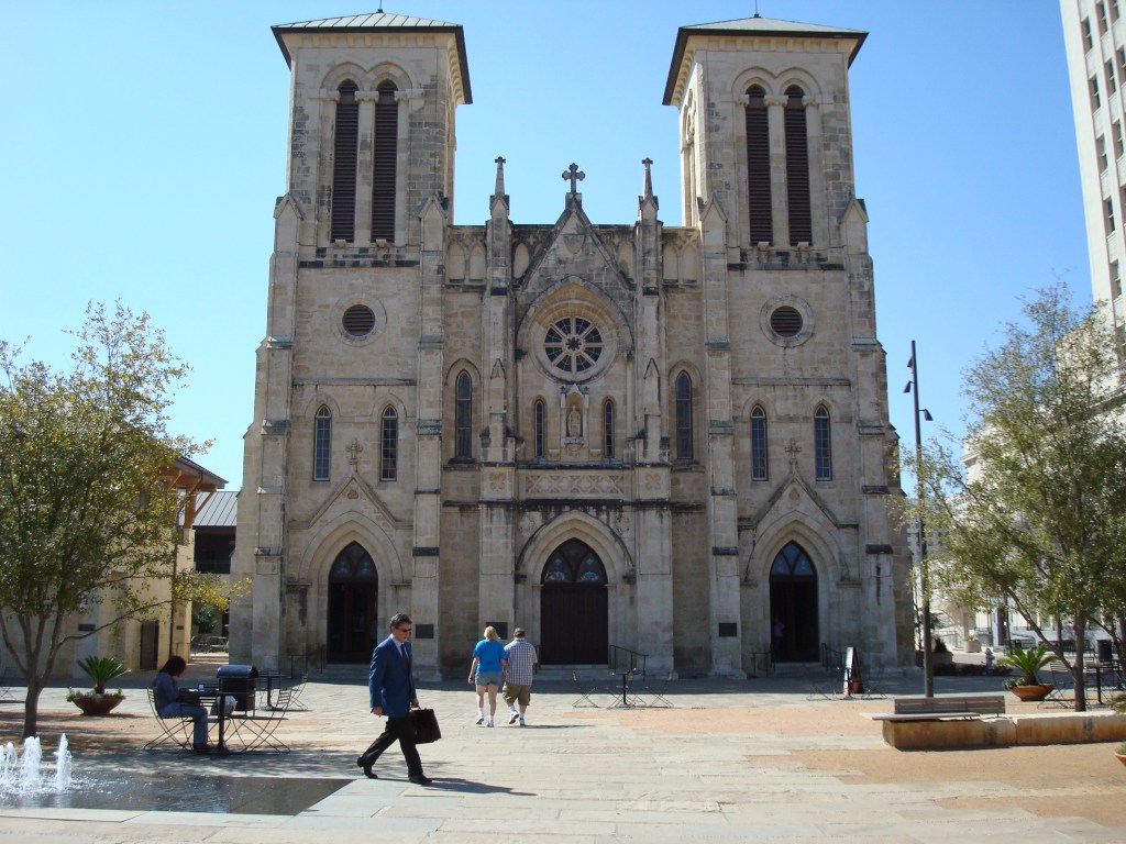
Photo by author
Construction on the San Fernando Church began in 1738. It was built to handle the religious needs of the ever-expanding population of the town. The first mass in the church was held in 1750, years before the Mission San Antonio de Valero’s (the Alamo) church was even started.
The original church only had a single bell tower on its south side. In Alamo history, it was from that bell tower that Santa Anna’s troops were sighted approaching the town on February 23rd. And it was also from this bell tower that Santa Anna flew his blood-red banner of “No Quarter.”
After the Battle of the Alamo, the church fell into hard times, and by 1840, the building was in significant disrepair due to its neglect. However, that same year, the church’s new administration began an extensive program of repairing the building.
In 1868, the church began extensive renovation and expansion. Local architect Francois P. Giraud was contracted to redesign the structure. Giraud’s concept was a Gothic Revival: triple entrance doors, gable roof, buttresses, and twin bell towers. To accomplish this, he removed most of the church’s original nave and also its historic single bell tower. What you see today is Giraud’s renovations.
On my first visits to the San Fernando Cathedral, I had thought that all remnants of the church of 1836 had been lost forever. I had only entered the front doors of the cathedral to see the marble sarcophagus, believed to hold the ashes of Alamo defenders, in its side anteroom. Sadly, I had not gone into the cathedral itself or even walked behind the building. By not doing this, I missed a major historical aspect simply by not taking action.
The Original San Fernando Church
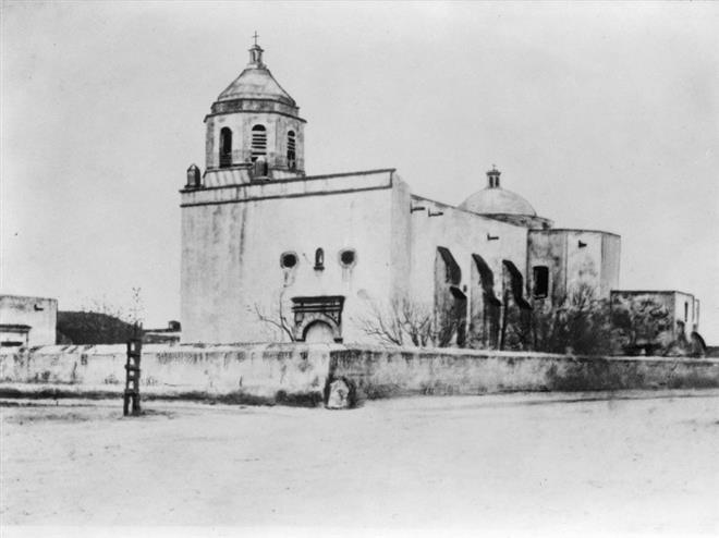
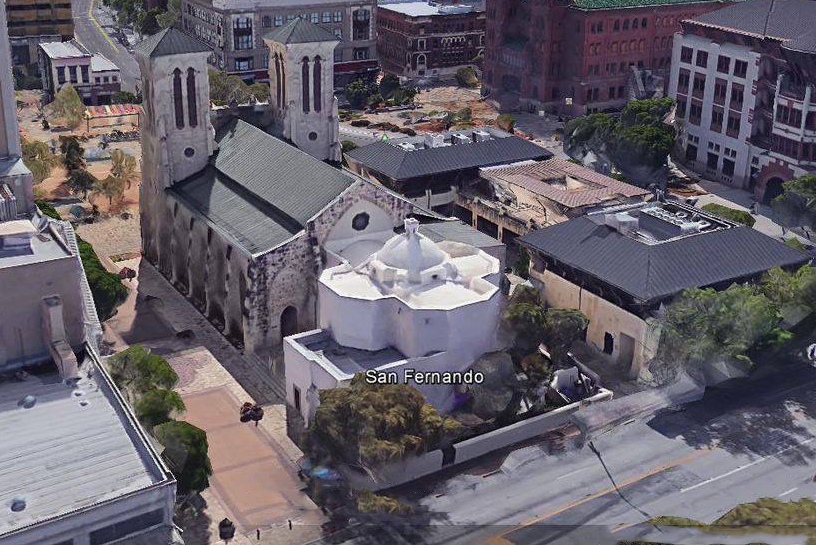
Thanks to Dean Kirkpatrick’s book, I learned that Giraud hadn’t completely torn down all of the church’s original structure to build his cathedral. Giraud had retained the church’s original: chancel, apse, altar, and sacristy. Even the exterior was the same as it was when Santa Anna occupied the town during the battle.
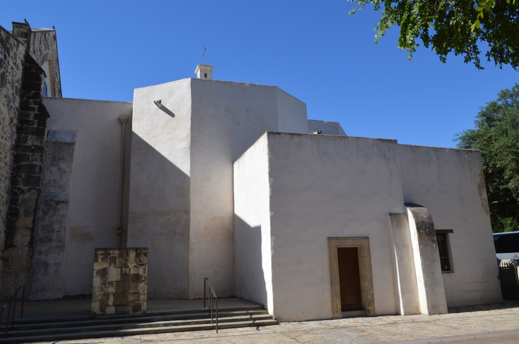
Photo by author
To see what remains of the original church, we need to simply walk around to the back. Just take the walkway on the north side of the cathedral to South Flores Street, and there it is. You can see where Giraud had married his additions to the original building (See map #12), which still stands much as it did in the 1700s, but most importantly, as it was in 1836. Now, we’ll go back around to the front and go inside, where we will discover even more.
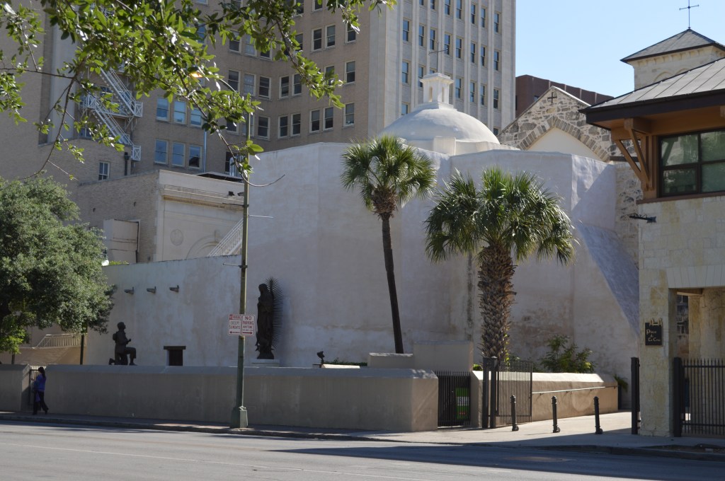
Photo by author
Inside, while standing at the back of the nave, you’re seeing what the Alamo heroes saw when they stood there, for the altar area has been preserved. In the center of the aisle, near the front pews, you’ll find a plaque in the floor. This marks the location of the front of the old church. When you pass this marker, you are now standing in what was the original church. It’s here, in front of the altar, where James Bowie had married Ursula de Veramendi in 1831.
The cathedral offers guided tours of the building. However, if there isn’t a mass being held or another function, you’re more than welcome to walk around and take in this historical masterpiece.
We have one last stop to visit with this post, the San Fernando Parish’s first Campo Santo.
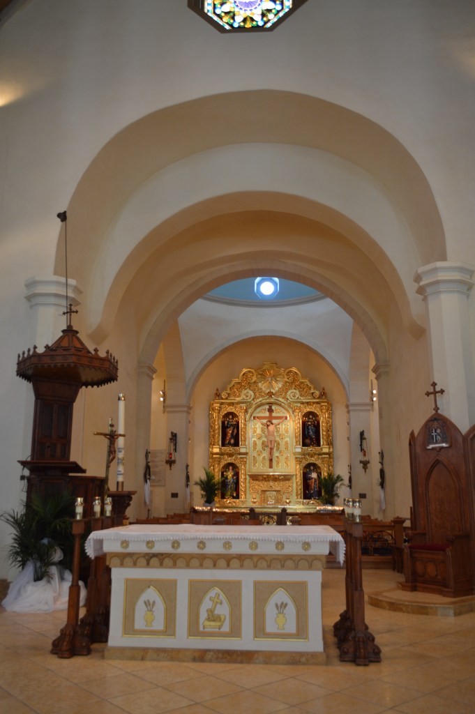
Photo by author
Also, before you leave, don’t forget to go into the small room at the back, on the right. It’s there where you’ll find the marble sarcophagus I spoke of earlier. I’ll be exploring more about this sarcophagus in my future post on what happened to the Alamo’s defenders’ remains.
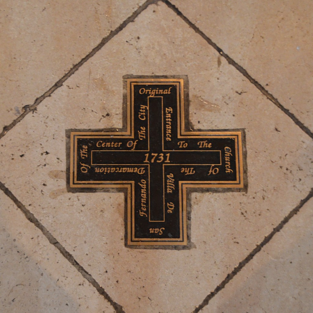
Photo by author
To get to the site of the old Campo Santo, we’ll continue west on East Commerce Street. But before we head up Commerce, I want to point out another lost Alamo historic site.
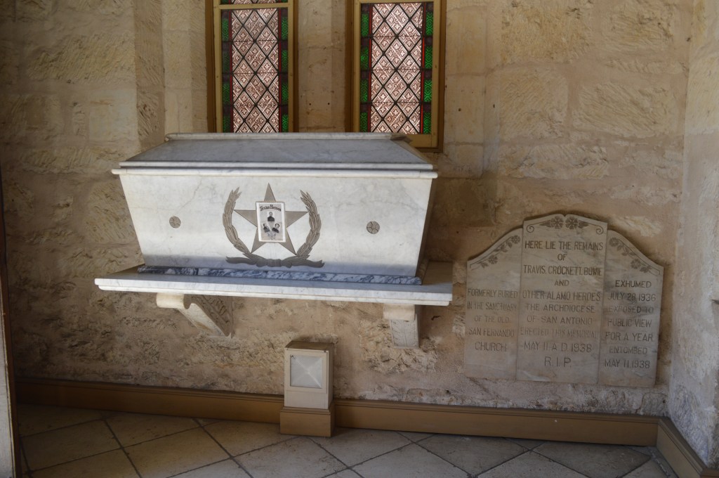
Photo by author
General Santa Anna’s Headquarters
When you get to the north side of the Main Plaza, look across the street. It was there, on the northeast corner of Commerce and North Main Avenue, where the old Yturri house (See map #13) had stood. This long-gone building was the headquarters of General Santa Anna during the Alamo battle. This site is not to be confused with the other historic Yturri-Endmunds House.
In my next post in this series, we’ll go just a bit further west, as we try to discover “The Lost Cemeteries of San Antonio.”
And if you missed the first post in this series, be sure to read it: My Updated, and Expanded, Walking Tour of the Alamo, Part 1: The Alamo Compound.
Sources used:
Huffines, Alan C. Blood of Noble Men, The Alamo, Siege & Battle. First Edition, Eakin Press, 1999.
Kirkpatrick, Dean. The Alamo Story and Battleground Tour. First Edition, NDK Publications, 2013.
“Carrie Nation.” Wikipedia, Wikipedia, 26 Nov. 2019, en.m.wkipedia.org/wiki/Carrie_Nation
Gobetz, Wally. “San Antonio-La Villita: Cos House.” Flicker, Flicker, http://www.flicker.com/photo/wallyg/42010385505
“History of Drury Hotel San Antonio Riverwalk.” Drury Hotels , Drury Hotels, druryhotels.com
“History of San Antonio.” History of San Antonio, Wikipedia, Sept. 2019, en.m.wikipedia.org/wiki/History_of_San_Antonio
La Villita. “La Villita History.” La Villita; Shops-Art-Dinning, City of San Antonio, lavillitasanantonio.com
“Menger Hotel.” Wikipedia, Wikipedia, Sept. 2019, en.m.wikipedia.org/wiki/Menger_Hotel
“Our History.” The Historic Menger Hotel, The Menger Hotel, mengerhotel.com
Reveley, Sarah. “Hallowed Ground: Site of Alamo Funeral Pyres Largely Lost to History.” Rivard Report, Rivard Report, 8 Jan. 2017, therivardreport.com/hallowed-ground-site-of-alamo-funeral-lost-to-history/
“Rough Riders.” Wikipedia , Wikipedia, 22 Nov. 2019, en.m,wikipedia.org/wiki/Rough_Riders
San Fernando Cathedral . “Our History.” San Fernando Cathedral, The Heart of San Antonio, San Fernando Cathedral, sfcatheral.org
Scott, J.M. “Theodore Roosevelt arrives in San Antonio to lead the “Rough Riders” on this day in 1898.” MySA, San Antonio Express-News, 16 May 2016, http://www.mysanantonio.com/news/local/history-culture/article/Theodore-Roosevelt
“Spanish-American War.” Spanish-American War, Wikipedia, 27 Nov. 2019, en.m.wikipedia.org/wiki/Spanish%E2%80%93American_war

Thank you for this. From comments in your posts regarding previous visits, I gather that you do not live near San Antonio. I have been looking for information about the original physical layout of the fort vs the city today and your previous post about the Alamo itself is very informative in that regard. I’m also interested in the pueblo of Bexar at the time of the battle. I’ve read mentions of the main plaza, Soledad Street and Flores but it’s hard to find info on the boundaries of that time.
LikeLike
Thank for the kind comments Scott. And you’re correct, I don’t live in San Antonio, I live in Michigan. As for Bexar’s town limits check out the book, The Blood of Nobel Men.
LikeLike
This really answered my downside, thank you!
LikeLike