“Where workmen are excavating for the cellar of a new building that will stand on the spot of one of the two funeral pyres whereon the bodies of those slain in the Alamo’s defense were consumed, is one of the memorable places of San Antonio, never marked and constantly passed unheeded. Few know that such a prominent event in history was there enacted. It will not be long before this spot, and the one where the other funeral pyre was built will be the sites of buildings for commercial purposes, and the populace, in all probability, will forget that either place was ever of such historical interest.”
Charles Merritt Barnes, from his article Builders’ Spades Turn Up Soil Baked by Alamo Funeral Pyres, San Antonio Express newspaper, 1911.
Historian and reporter Charles Barnes’s 1911 prophecy about the fate of the two sites of the Alamo defenders’ funeral pyres has sadly come true tenfold. That building, where he witnessed the basement being dug, is now long gone. In fact, that spot and the site of the second pyre have been built on multiple times over the decades since Barnes’s article.

It’s hard to envision that today’s E. Commerce Street, with its restaurants, office buildings, hotels, and a major shopping mall, once had a section of flowering cottonwood trees and was the site of a horrific cremation. But those who would like to visit the sites of those two pyres amongst this urban landscape will be greatly disappointed. Because, as I told in my last post, A DAUNTING TASK, the only identifying marker to that event isn’t even on the actual sites.
For this reason, discovering where those two pyres had been on E. Commerce Street has been challenging, fun, and rewarding. The challenge comes from the drastic commercial development that’s taken place over the nearly 200 years since the Battle of the Alamo. As I stated in my last post, this has eliminated buildings and streets, which would have been helpful landmarks for my search.
It has also been fun to discover the many eyewitness accounts and the historic Sanborn Fire Insurance maps for San Antonio. These sources and others have helped me identify where these important historical sites in Alamo history would have been along that busy road. But most of all, it will be rewarding if my work inspires you to visit these sites and pay homage.
In A DAUNTING TASK, we learned how Santa Anna’s soldiers had dragged the bodies of the Alamo defenders to a cottonwood tree-lined road known as the Alameda, where they cremated their remains on two funeral pyres. So, to find the sites of the two funeral pyres, we first need to find the Alameda.
The Alameda
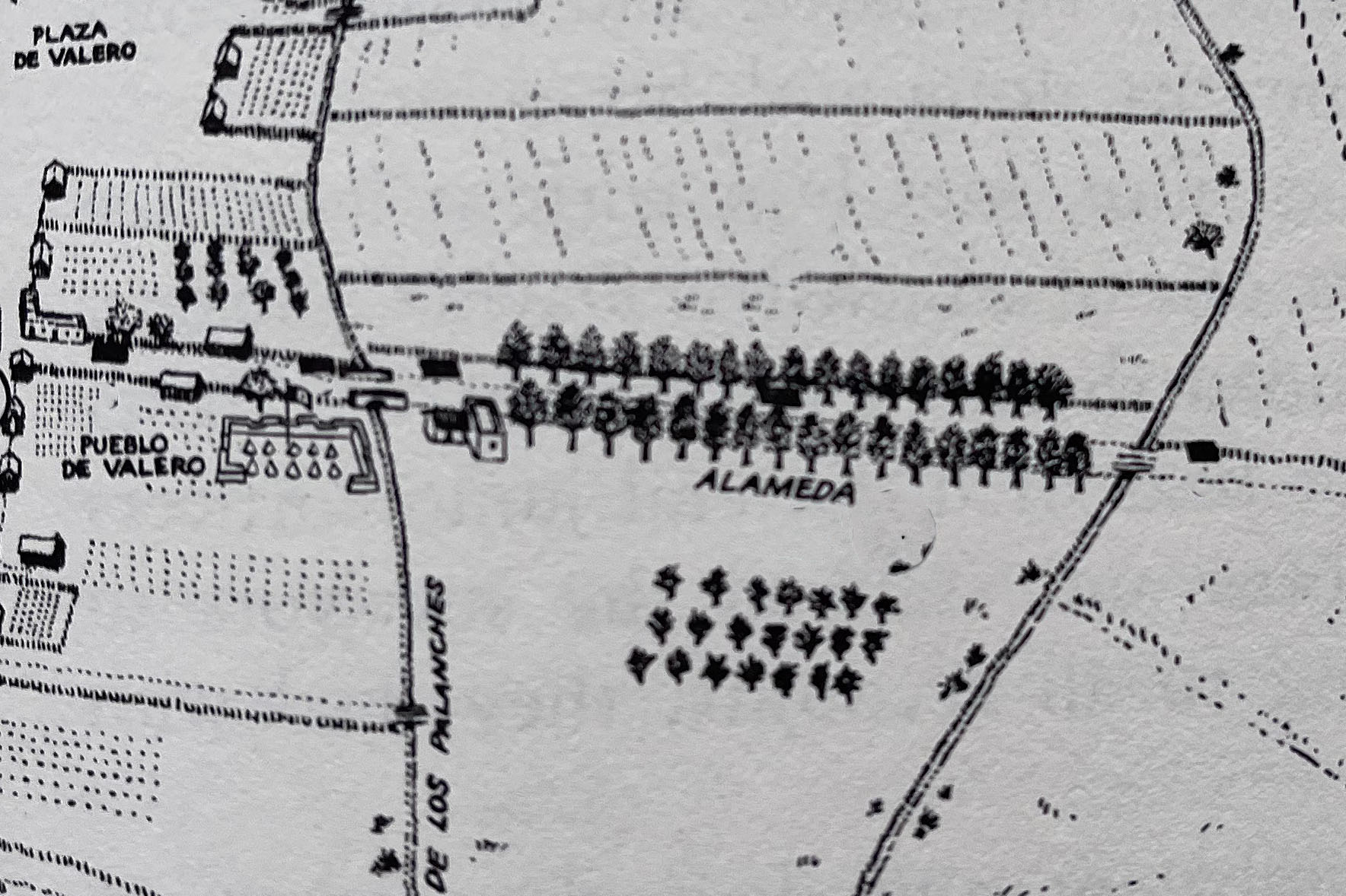
On Sundays, holidays, and special occasions, the townsfolk of Pueblo de Valero, La Villita, and San Antonio de Béxar would gather along the quiet cottonwood-tree-lined section of road known as the Alameda. There, amongst its flowering trees, they would walk, picnic, play games, and dance. Today, there’s no evidence of this once popular place to gather and relax along E. Commerce Street. With no physical evidence remaining as to where the Alameda had been, I relied on written accounts and the 1888 Sanborn Fire Insurance map of San Antonio to help in my search.
Finding the Alameda
As I mentioned in my previous post, the Alameda was situated east of the small jacal community of Pueblo de Valero, specifically on what was then the Old Powder House, or Gonzalez Road (Figure #1)
Historical accounts also indicate that the Alameda spanned approximately 1,000 feet. However, what’s crucial for our search is the Alameda’s position between two branches of the Acequia Madre or Acequia del Valera, the Alamo mission’s irrigation system. These branches were the Alamo Acequia and the Acequia Madre. Therefore, in our quest to locate the Alameda, our primary task is to identify where the two irrigation ditches would have been.
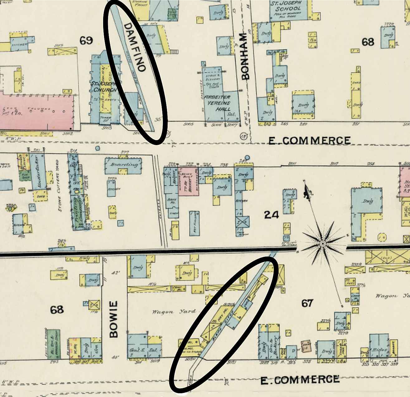
I found the Alamo Acequia and the Acequia Madre on Sheet #10 of the 1888 Sanborn map of San Antonio. Sheet #10 has E. Commerce Street divided into three sections. The two branches, listed simply as “Alamo ditch,” are on the top and center sections. On the top section, the western Alamo Acequia can be seen running along a street named Damfino. The center section has the eastern irrigation ditch, the Acequia Madre, being east of Bowie Street. I’ve circled those two ditches on the map (Figure #2).
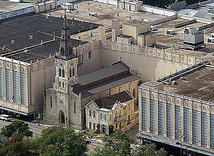
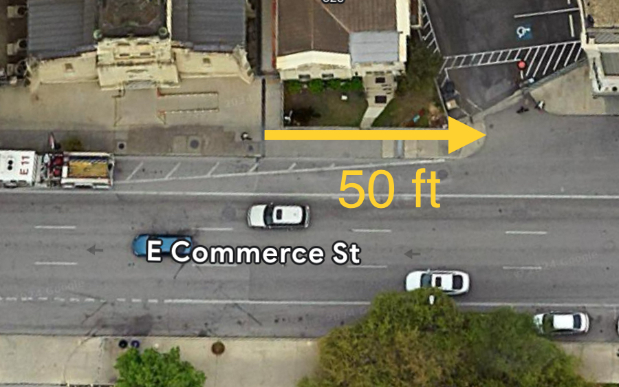
To pinpoint the location of the western irrigation ditch, I needed a reference point that not only appeared on the 1888 map but also exists today. Although Damfino Street is no longer present, St. Joseph Catholic Church remains. Using the map’s scale, I measured east from St. Joseph Church to the Alamo ditch. This distance was approximately 50 feet. I then used the Google satellite map of E. Commerce Street and its measuring tool to move 50 feet east from St. Joseph Church. This led me to a small parking lot east of the church building (figure #3). This would have been the Alamo Acequia’s location and the western end of the Alameda.
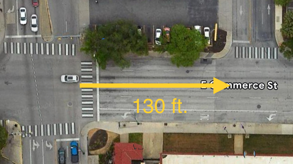
To find the eastern Acequia Madre, I repeated the process I used to find the western Alamo Acequia. On the center section of the map, the common reference point still present today is Bowie Street. Using the map’s scale, I measured east from Bowie to the Alamo ditch. This came to around 130 feet. Returning to the Google map, I measured east from Bowie Street 130 feet along E. Commerce, which took me to Elm Street (Figure 4). Elm Street would have been the Acequia Madre’s location and the Alameda’s general eastern end. But how accurate are my calculations? There was a way to check.
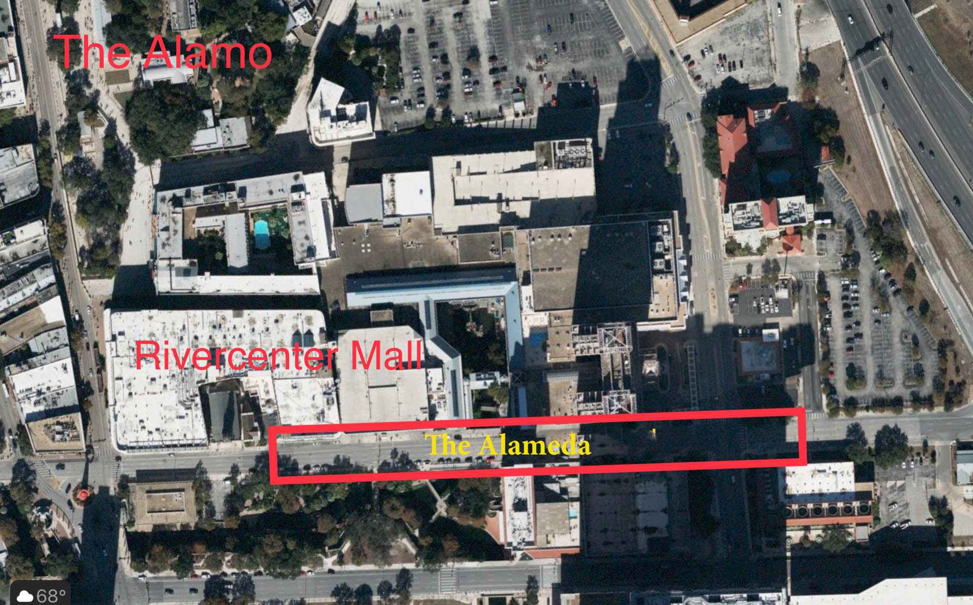
As I said earlier, accounts tell that the length of the Alameda was around 1,000 feet between the two ditches. With this information, I measured the distance from the small parking lot by St. Joseph Church east to Elm Street on the Google map. This came to a little over 1135 feet. Considering the margin of error, my findings seem very close. I’ve marked where I believe the Alameda would have been on E. Commerce Street (Figure # 5)
The Funeral Pyres of the Alamo Defenders
Now that we’ve located where the Alameda had been along E. Commerce Street, it’s time to discover the sites where Santa Anna’s soldiers cremated the Alamo defenders’ bodies on the two funeral pyres.
In my next two posts in this series, I’ll use written and eyewitness accounts, historic Sanborn maps, and the invaluable 1984 University of Texas’s Rivercenter Mall archaeological report to determine where on E. Commerce Street those two pyres would have been.
BIBLIOGRAPHY:
The cover photo is the Alameda by Hermann Lungkwitz (1813-1891)
Hansen, Todd. “Francisco Antonio Ruiz 1860 account.” The Alamo Reader, A Study in History First Edition, STACKPOLE BOOKS, 2003, p. 501.
Hansen, Todd. “Pablo Díaz 1906 interview. The Alamo Reader, A Study In History, First Edition, STACKPOLE BOOKS, 2003, p. 530.
Huffines, Alan C. “DAY FIVE MAP.” The Blood of Noble Men, The Alamo, Siege & Battle, Gary S. Zaboly, First Edition, Eakin Press, 1999, p. 71.
Huffines, Alan C. “DAY THIRTEEN.” The Blood of Noble Men, The Alamo, Siege & Battle, First Edition, 1999, p. 134.
Huffines, Alan C. . “DAY THIRTEEN.” The Blood of Nobel Men, The Alamo, Siege & Battle, First Edition, Eakin Press, 1999, p. 195.
Huffines, Alan C. “DAY THIRTEEN.” The Blood of Nobel Men, The Alamo, Siege & Battle, first Edtion, Eakin Press, 1999, p. 200.
Huffines, Alan C. “FIG.14 THE BURNING OF THE JACALES, FEBRUARY 26.” The Blood of Nobel Men, The Alamo, Siege & Battle, First Edition, Eakin Press, 1999, p. 68.
Huffines, Alan C. “Map of the Alameda.” Blood of Noble Men, The Alamo Siege & Battle, illustrated by Gary S. Zaboly, First Edition, Eakin Press, 1999, p. 133.
Matovina, Timothy M. “The Burning of the Bodies’ The Alamo Remembered, Tejano Accounts and Perspective, University of Texas Press, Austin, 1995, p. 104.
jrboddie. “The Alameda .” Alamo Studies Forum, Alamo Studies Forum, 17 Apr. 2014, alamostudies.proboards.com/thread/1674/alameda.
Reveley, Sarah. “Hallowed Ground: Site of Alamo Funeral Pyres Largely Lost to History .” San Antonio Report, San Antonio Report, 7 Jan. 2017, sanantonioreport.org/hallowed-ground-site-of-alamo-funeral-pyres=largely-lost-to-history/.
Sanborn Fire Insurance Company. “Perry-Castaneda Library Mao Collection.” 1888 San Antonio Map Sheet #10, The University of Texas Libraries, maps.lib.utexas.edu/maps/sanborn/s-t/txu-sanborn-san_antonio-1888-10.jpg. Accessed 6 May 2023.

thank you for your hard work
LikeLike
Thank you for reading
LikeLike
This is very compelling. Thank you for researching and publishing this.
LikeLike
Thank you so much for reading my work.
LikeLike
Thank you
LikeLike