We left the archaeological site of Delphi and began heading to our next stop, the ancient site of Olympia. Ancient Olympia is located in the Peloponnese, the large southern peninsula of Greece. When you first glance at a map of Greece you might think that the Peloponnese is an island, but it’s not. The Peloponnese is joined to mainland by the small 3.9 mile wide Isthmus of Corinth. The word “Isthmus” is Greek for “neck”, which this narrow land bridge is, a very small neck of land. In the past ships had to sail around the Peloponnese to get to the western side of the country.
Throughout history many have tried to shorten this voyage by going across the Isthmus. The first efforts was to haul the ships overland using logs and a flatted road. In 67 AD the Roman Emperor Nero made the first attempt to dig a canal with 6,000 slaves using only spades. Nero’s efforts only got a mere 5/8 km in length before he died and the project was discontinued. After Greece won its independence from Ottoman Empire the project was once again proposed and with the help of the French the Corinth Canal was completed in 1893, after eleven years of construction.
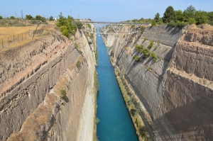
 the Corinth Canal: 3.9 miles long, 82 feet wide, 300 feet from the water to the top
The canal is only a single channel, 82 feet wide. Only one ship can travel through it going one way. The entire 3.9 mile length of the canal is at sea level, eliminating the need for locks to raise or lower ships. The walls the of the Corinth Canal rise up 300 feet from the water to the top edge, making it a very impressive sight when viewing it from one of the bridges that crosses it.
The only other way that was available to get to the Peloponnese rom the mainland was by ferry across the Gulf of Corinth. The ferries ran between the cities of Antirrio, on the mainland, and Rio, on the Peloponnese side. This all changed in 2004 with the opening of the Rio-Antirrio Bridge. A bridge that would connect the mainland with the Peloponnese was first envisioned by 19th Century Greek Prime Minister, Charilaos Trikoupis. The official name for the new bridge is “the Charilaos Trikoupis Bridge” in his honor. Although the bridge is only 1.8 miles long it is considered to be the longest cable-stayed suspended deck bridge in the world. To complete this task the Greeks again called upon the French for help in the building and the design of this engineering masterpiece.
 the Rio-Antirrio Bridge/Charilaos Trikoupis Bridge
There were many challenges that faced the engineers: deep water, a weak sea floor for the foundations, seismic activity, and with that a chance of tsunamis’. Construction began in July of 1998 and completed on August 7, 2004, the week before the opening of the Summer Olympics in Athens. In fact the first to cross the new bridge where the Olympic torchbearers’ bring the Olympic flame to Athens from Ancient Olympia.
Now there is easy access from the mainland to the Peloponnese in both the east and the west sides of Greece. And ships cut their time when sailing between the Aegean Sea on the east and the Ionian Sea on the west by using the canal. Both areas of Greece are now truly connected.
Outstanding post however , I was wanting to know
if you could write a litte more on this topic? I’d be very grateful if you could elaborate a little bit more.
Many thanks!
LikeLike
Thank you so much. Sorry for the lateness of my reply, I am still learning how to get around this site.
LikeLike
Thank you for your kind words. Sorry that it has taken so long to reply, your comment was in the spam folder. I am still learning my way around Word Press.
My posts are going to be mostly a travel log, with a little history and locals facts that I picked up tossed in. I will be continuing Greece after I finish my Alamo posts.
LikeLike